What Is Latitude? Everything You Need to Know
Have you ever wondered how maps are drawn so precisely or why certain regions experience drastically different climates despite being at similar longitudes? What is latitude, and why is it a fundamental concept in geography, navigation, and even climate science? Whether you’re a student, a geography enthusiast, or simply curious about how our world is measured and understood, this comprehensive guide will provide you with everything you need to know about what is latitude. In this article, we’ll explore the definition of latitude, its essential characteristics, historical evolution, real-world applications, and modern relevance. By the end, you’ll have a deep understanding of latitude and its pivotal role in shaping how we perceive and navigate our planet.
Introduction: Mapping Our World with Invisible Lines
Imagine trying to travel from one city to another without a map or a compass. How would you know where to go? Our understanding of the world’s geography depends on invisible lines—lines that help us pinpoint locations and understand our planet’s layout. One of these crucial lines is latitude.
Did you know that the concept of latitude has been essential to navigation and cartography for thousands of years? From ancient mariners who relied on the stars to modern GPS systems that guide our every move, latitude is at the heart of global positioning and geographic information systems (GIS). In this guide, we will cover:
- A clear and straightforward definition of latitude and its core components.
- The essential characteristics that define what latitude is and how it is measured.
- A historical and contextual background tracing the evolution of latitude from ancient astronomy to modern satellite navigation.
- An in-depth exploration of the different aspects of latitude, including its role in mapping, climate classification, and navigation, along with real-world examples and case studies.
- The importance, applications, and benefits of understanding latitude in everyday life, science, business, and global communication.
- Common misconceptions and FAQs to dispel myths and clarify what latitude truly represents.
- Modern relevance and current trends in the study and application of latitude, including advances in digital mapping and geospatial technology.
- A conclusion summarizing the key points and a call-to-action for further exploration and discussion.
By the end of this guide, you’ll not only know what is latitude but also appreciate how these invisible lines help us organize, navigate, and understand our world. Let’s embark on this journey into the fascinating realm of latitude!
Section 1: Defining Latitude
What Is Latitude?
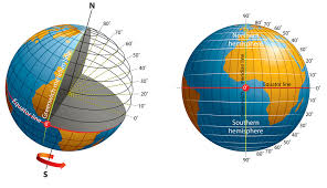
At its simplest, latitude is a geographic coordinate that specifies the north–south position of a point on the Earth’s surface. It is expressed in degrees, with the Equator defined as 0° latitude, the North Pole as 90°N, and the South Pole as 90°S.
Straightforward Definition:
Latitude is the measure of how far a location is from the Equator, expressed in degrees. It is one of the two coordinates (the other being longitude) used in the geographic coordinate system to pinpoint the exact location of a place on Earth. Latitude lines, also known as parallels, run east to west and are equidistant from each other.
Essential Characteristics of Latitude
When discussing what is latitude, several key characteristics come to light:
Angular Measurement:
Latitude is measured in degrees (°), minutes (‘), and seconds (“). Each degree is subdivided into 60 minutes, and each minute into 60 seconds. This precision allows for accurate location mapping.Parallel Lines:
Lines of latitude are imaginary circles that run parallel to the Equator. They remain equidistant from one another, which simplifies calculations and mapmaking.Reference Point – The Equator:
The Equator is the primary reference line for latitude. It divides the Earth into the Northern and Southern Hemispheres and is the starting point (0° latitude) for measuring distance north or south.Variation in Climate and Daylight:
Latitude has a significant impact on climate, weather patterns, and the amount of daylight a region receives. Areas near the Equator tend to be warmer with less variation in daylight hours, while regions at higher latitudes experience more extreme seasonal changes.Navigation and Cartography:
Latitude is a fundamental component in navigation and mapping. Mariners, aviators, and explorers rely on latitude (along with longitude) to determine their precise location and chart their course.
Understanding these characteristics provides the groundwork for appreciating what is latitude and its multifaceted role in our understanding of the Earth.
Section 2: Historical and Contextual Background
The Origins and Evolution of Latitude
The concept of latitude has a long history that spans ancient civilizations to modern satellite navigation. Its evolution reflects humanity’s growing understanding of the Earth and our need to measure and navigate it accurately.
Early Discoveries and Ancient Astronomy
Ancient Civilizations:
Early civilizations, such as the Egyptians and Babylonians, observed the stars and the sun to estimate time and seasonal changes. They used basic astronomical observations to develop early methods of measuring the Earth’s dimensions.Greek Contributions:
The ancient Greeks made significant contributions to the concept of latitude. Greek astronomers and geographers, like Eratosthenes, used observations of the sun’s angle at different locations to estimate the Earth’s circumference. These early calculations laid the foundation for more precise measurements of latitude.Medieval and Islamic Advances:
During the medieval period, Islamic scholars further refined astronomical instruments and methods. They made more accurate observations of celestial bodies, which improved the measurement of latitude and aided navigation.
The Renaissance and the Age of Exploration
The Rebirth of Science:
The Renaissance saw a revival in scientific inquiry and exploration. European explorers relied on improved navigational tools, such as the astrolabe and sextant, to measure latitude at sea. This enabled more accurate maps and contributed to the era of global exploration.Impact on Navigation:
The ability to measure latitude accurately was crucial for long-distance voyages, as it helped sailors determine their north-south position and navigate safely across vast oceans.
Modern Developments
Advancements in Technology:
In the modern era, the invention of the Global Positioning System (GPS) and satellite navigation has revolutionized how we determine latitude. These technologies use a network of satellites to provide precise geographic coordinates anywhere on the planet.Digital Mapping and GIS:
The rise of digital mapping tools and Geographic Information Systems (GIS) has made it easier than ever to utilize latitude (and longitude) in various applications, from urban planning to environmental monitoring.
Notable Historical Anecdotes
Eratosthenes’ Measurement of the Earth:
One of the earliest known uses of latitude was by the Greek mathematician Eratosthenes, who, in the 3rd century BCE, used the angle of the sun at noon in two different locations to estimate the Earth’s circumference with remarkable accuracy.Navigational Breakthroughs:
The development and refinement of the sextant during the Age of Exploration greatly improved sailors’ ability to determine latitude, enabling the successful navigation of the oceans and the mapping of uncharted territories.Modern Satellite Navigation:
The launch of the first GPS satellite in 1978 marked a turning point in navigation. Today, GPS technology, which relies on precise measurements of latitude and longitude, is embedded in everything from smartphones to autonomous vehicles.
For additional historical context on latitude, consider exploring resources such as the History Channel’s Geography Section and articles on ancient astronomy available on NASA’s website.
Section 3: In-Depth Exploration of Latitude
Understanding what is latitude involves exploring its measurement, how it’s used in various fields, and the different types of latitude lines that help us navigate our planet.
Measuring Latitude
Degrees, Minutes, and Seconds
Degrees (°):
Latitude is measured in degrees, with the Equator at 0° and the poles at 90°N (North Pole) and 90°S (South Pole).Minutes (‘) and Seconds (“):
Each degree is divided into 60 minutes, and each minute into 60 seconds, allowing for precise measurement. For example, a location might be described as 37°46’30” N, indicating its exact position north of the Equator.
Tools and Techniques
Astronomical Observations:
Historically, tools like the astrolabe and sextant were used to measure the angle of the sun or stars above the horizon, allowing navigators to calculate latitude.Modern GPS:
Today, GPS devices use signals from satellites to determine your exact geographic coordinates, including latitude. This technology is highly accurate and is used in everything from car navigation systems to mobile phones.
Types of Latitude Lines
1. Parallels
Definition:
Lines of latitude, also known as parallels, are imaginary lines that run east to west across the globe. They are parallel to the Equator and remain equidistant from one another.Examples:
- The Equator (0° Latitude):
The most significant parallel, dividing the Earth into the Northern and Southern Hemispheres. - The Tropic of Cancer (approximately 23.5°N) and the Tropic of Capricorn (approximately 23.5°S):
These lines mark the boundaries where the sun can appear directly overhead at noon. - The Arctic Circle (approximately 66.5°N) and the Antarctic Circle (approximately 66.5°S):
These parallels mark the regions of the Earth where, for at least one day a year, there is continuous daylight or darkness.
- The Equator (0° Latitude):
2. Latitude and Climate
Climatic Zones:
Latitude plays a critical role in determining climate. Regions near the Equator tend to have warm, tropical climates, while higher latitudes experience more pronounced seasonal variations, including cold winters.Daylight Variation:
The amount of daylight a region receives is heavily influenced by its latitude. For example, areas at high latitudes experience extreme variations in daylight throughout the year, affecting agriculture, lifestyle, and energy consumption.
Real-World Applications and Case Studies
Example 1: Navigation and Exploration
Historical Navigation:
Early explorers, such as Christopher Columbus and Ferdinand Magellan, relied on measuring latitude (and longitude) to navigate the vast oceans. Their discoveries were possible because they could determine how far north or south they had traveled, ensuring they remained on course.Modern GPS Systems:
Today, navigation systems in cars, smartphones, and ships rely on accurate latitude measurements provided by GPS technology. This allows for precise routing and efficient travel, significantly reducing travel time and enhancing safety.
Example 2: Climate and Environmental Studies
Climate Zones:
Scientists study latitude to understand global climate patterns. For example, researchers use data from various latitudes to model weather systems, study climate change, and develop strategies for environmental conservation.Case Study:
The study of polar regions—areas at the extreme latitudes of the Arctic and Antarctic—has provided critical insights into climate change. Researchers track changes in ice cover, temperature fluctuations, and ecosystem dynamics to better predict the impacts of global warming.
Example 3: Urban Planning and Infrastructure
City Design:
Urban planners use latitude data to design cities that optimize sunlight, manage weather patterns, and enhance energy efficiency. For example, cities at higher latitudes might incorporate designs that maximize natural light during shorter days.Renewable Energy:
The positioning of solar panels and wind turbines is influenced by latitude, as it affects the intensity and duration of sunlight and wind patterns. This helps optimize energy production and sustainability efforts.
For further exploration of latitude and its applications, you might refer to resources like the National Oceanic and Atmospheric Administration (NOAA) and NASA’s Earth Observatory.
Section 4: Importance, Applications, and Benefits of Understanding Latitude
The Critical Role of Latitude in Everyday Life
Understanding what is latitude is essential because it influences many aspects of our lives, from the climate we experience to the navigation systems that guide our journeys. Here’s why latitude matters:
Navigation and Travel
Precise Positioning:
Latitude, combined with longitude, provides a precise coordinate system that helps us locate any point on the Earth. This system is the foundation of modern navigation and mapping.Global Connectivity:
Without latitude, global positioning systems (GPS) would not function. This technology is indispensable for travel, shipping, and logistics, ensuring that goods and people reach their destinations efficiently.
Climate and Environmental Management
Weather Patterns:
Latitude determines the amount of sunlight and the angle at which it strikes the Earth, influencing temperature, precipitation, and seasonal variations. This is crucial for agriculture, urban planning, and energy management.Environmental Research:
Scientists use latitude to study climate zones, track changes in polar ice caps, and model global climate change. This information is vital for developing strategies to mitigate the impacts of climate change.
Economic and Social Impacts
Urban Planning:
Latitude data helps architects and city planners design structures and urban layouts that take advantage of natural light, manage energy efficiency, and cope with local weather patterns.Cultural Diversity:
Different latitudes host diverse ecosystems and cultures. Understanding these variations enriches our knowledge of global diversity and helps foster a deeper appreciation for the interconnectedness of our world.
Benefits for Decision-Making
Informed Choices:
Whether you’re planning a vacation, investing in real estate, or studying environmental science, knowledge of latitude enables you to make informed decisions based on location-specific factors.Technological Innovation:
Advances in geospatial technologies and digital mapping have made latitude data more accessible than ever, empowering businesses, governments, and individuals to leverage this information for planning and innovation.
For more detailed discussions on the importance of latitude, check out the NOAA Climate.gov and USGS – The Geologic Time Scale.
Section 5: Common Misconceptions and FAQs About Latitude
Debunking Common Misconceptions
Despite its critical role, several misconceptions about what is latitude still persist. Let’s address some common myths and clarify the facts:
Misconception #1: Latitude and Longitude Are the Same.
Reality:
While both are geographic coordinates, latitude measures the north-south position relative to the Equator, whereas longitude measures the east-west position relative to the Prime Meridian.Misconception #2: Latitude Only Affects Climate.
Reality:
Although latitude has a major influence on climate, it also plays a crucial role in navigation, urban planning, and environmental research.Misconception #3: All Regions at the Same Latitude Have the Same Climate.
Reality:
While latitude is a key factor, other elements such as altitude, ocean currents, and local geography also significantly influence climate.Misconception #4: Latitude Is Only Relevant for Scientists and Navigators.
Reality:
Understanding latitude is useful for everyone—from travelers planning a trip to businesses assessing potential locations for new ventures.
Frequently Asked Questions (FAQs)
Q: What is latitude?
A: Latitude is a geographic coordinate that specifies the north-south position of a point on the Earth’s surface, measured in degrees from the Equator (0°) up to the poles (90°N or 90°S).Q: How is latitude measured?
A: Latitude is measured in degrees (°), with further subdivisions into minutes (‘) and seconds (“). Modern measurements are obtained using satellite systems like GPS, as well as traditional astronomical methods.Q: Why is latitude important?
A: Latitude influences climate, weather patterns, and the amount of daylight a region receives. It is also essential for navigation, mapping, and many scientific studies.Q: How do latitude and longitude work together?
A: Together, latitude and longitude form the geographic coordinate system, allowing for the precise location of any point on Earth. Latitude provides the north-south position, while longitude provides the east-west position.Q: Can latitude affect local weather?
A: Yes. Regions closer to the Equator generally have warmer temperatures and less variation in daylight, while higher latitudes experience more extreme seasonal changes.
Section 6: Modern Relevance and Current Trends in Latitude
Latitude in Today’s Digital and Global World
In our rapidly evolving world, understanding what is latitude continues to be of paramount importance. Modern technologies and global challenges have made latitude data more accessible and essential than ever before.
Advances in Geospatial Technology
Global Positioning Systems (GPS):
GPS technology relies on precise latitude and longitude measurements to provide real-time location data. This has revolutionized navigation, logistics, and emergency response systems.Geographic Information Systems (GIS):
GIS technology uses latitude data to analyze and visualize spatial information, aiding in urban planning, environmental monitoring, and resource management. Digital maps and location-based services are now integral to everyday life.Satellite Imaging and Remote Sensing:
Modern satellites capture high-resolution images of the Earth, enabling scientists to study geographic and climatic patterns with unprecedented accuracy. Latitude data is key to interpreting these images and monitoring changes in the environment.
Globalization and Environmental Studies
Climate Change Research:
Latitude is critical for studying climate zones and understanding how global warming affects different regions. Researchers use latitude data to track changes in weather patterns, ice coverage, and sea levels.International Collaboration:
Global organizations and governments rely on latitude-based data to coordinate efforts in disaster relief, environmental protection, and sustainable development. This data supports initiatives aimed at addressing global challenges.
Digital Mapping and Everyday Applications
Navigation Apps:
Smartphone apps like Google Maps and Waze utilize latitude data to provide accurate directions, estimated travel times, and real-time traffic updates, making everyday travel more efficient.Location-Based Services:
Many digital services, including social media, retail, and public transportation apps, use latitude data to offer personalized, location-specific information to users.Cultural and Educational Projects:
Online educational tools and digital museums use latitude data to create interactive maps and historical timelines, enriching the learning experience and connecting people with their local and global heritage.
For up-to-date insights into modern geospatial trends, reputable sources such as the National Geospatial-Intelligence Agency (NGA) and Esri offer comprehensive resources on the latest technologies and research in this field.
Section 7: Practical Applications and Benefits of Understanding Latitude
Everyday Benefits and Opportunities
Understanding what is latitude provides numerous practical benefits, impacting a wide range of personal, academic, and professional activities:
Improved Navigation and Travel:
Whether you’re planning a road trip, hiking in the wilderness, or catching a flight, knowing how latitude works helps you understand maps and navigate effectively.Enhanced Geographic Literacy:
Knowledge of latitude enriches your understanding of geography, climate, and global diversity, enabling you to appreciate the nuances of different regions.Informed Decision-Making:
For businesses and policymakers, latitude data is crucial for urban planning, environmental management, and strategic investments. This information can guide decisions that impact everything from infrastructure development to disaster preparedness.Educational Empowerment:
Students and educators use latitude to study earth sciences, geography, and history. Accurate understanding of latitude supports better learning outcomes and inspires curiosity about the world.
Applications Across Various Domains
In Education
Geography and Earth Sciences:
Teachers use latitude to explain climate zones, map reading, and global navigation. Lessons on latitude help students grasp the spatial relationships that define our planet.Interactive Learning Tools:
Digital maps, virtual globes, and GIS platforms provide hands-on experiences with latitude data, making learning engaging and interactive.
In Business and Infrastructure
Urban Planning:
City planners use latitude information to design efficient transportation systems, optimize building layouts, and plan for sustainable development in different climatic zones.Agriculture:
Farmers and agricultural planners rely on latitude data to understand seasonal variations, plan crop rotations, and implement effective irrigation systems.
In Science and Environmental Research
Climate Studies:
Researchers use latitude to study global climate patterns, model weather systems, and predict the impacts of climate change on various regions.Biodiversity and Conservation:
Latitude is critical in understanding the distribution of species and ecosystems. Conservation efforts are often planned based on the unique climatic conditions defined by latitude.
In Everyday Life
Navigation Apps and Tools:
Everyday users benefit from GPS technology and mapping apps that rely on precise latitude data to provide accurate directions and location-based services.Travel and Tourism:
Travelers use latitude information to understand local climates and plan trips accordingly, ensuring a more enjoyable and informed travel experience.
For further practical guidance, websites like National Geographic and Google Earth offer engaging tools and resources that highlight the role of latitude in our world.
Section 8: Conclusion and Call-to-Action
Summarizing the Essentials
So, what is latitude? Latitude is a geographic coordinate that measures how far north or south a location is from the Equator, expressed in degrees, minutes, and seconds. It is an essential element of the geographic coordinate system, playing a critical role in navigation, climate determination, urban planning, and environmental research. Throughout this guide, we have:
- Provided a clear and concise definition of latitude and explained its core characteristics.
- Explored the essential properties of latitude, including its measurement, the concept of parallels, and its influence on climate and geography.
- Traced the historical evolution of latitude—from ancient astronomical observations and early navigational methods to modern satellite-based systems.
- Delved into an in-depth exploration of the different aspects of latitude, supported by real-world examples, case studies, and detailed explanations.
- Highlighted the importance, applications, and benefits of understanding latitude in everyday life, business, science, and education.
- Addressed common misconceptions and FAQs to clear up myths and clarify misunderstandings about latitude.
- Reviewed the modern relevance and current trends in the use of latitude, emphasizing advancements in digital mapping, GPS technology, and environmental studies.
The Importance of Understanding Latitude
Understanding what is latitude is crucial for a wide range of activities—from navigating unfamiliar territories and planning travel to conducting environmental research and making informed business decisions. Latitude is not just a number on a map; it is a key factor that influences climate, ecosystems, and human activities around the world.
Call-to-Action
Now that you have a comprehensive understanding of latitude, here are some actionable steps to further engage with this fascinating topic:
Educate Yourself Further:
Explore additional resources on geography and mapping by visiting reputable websites such as the National Oceanic and Atmospheric Administration (NOAA) and NASA’s Earth Observatory. Consider enrolling in online courses on GIS and geospatial analysis through platforms like Coursera or edX.Practice Using Digital Tools:
Experiment with digital mapping tools like Google Earth or ArcGIS Online to see how latitude (and longitude) helps you explore the world. These tools can provide hands-on experience with geographic data.Engage in Discussions:
Join online forums, social media groups, or local geography clubs where you can share insights, ask questions, and learn from others about latitude and other geographic concepts.Share This Guide:
If you found this post informative, please share it on social media, with colleagues, or with friends who might be interested in learning more about what is latitude. Spreading knowledge helps build a more informed and connected community.Subscribe for More:
Stay updated on the latest trends, research, and best practices in geography, mapping, and digital navigation by subscribing to our newsletter. Join our community of lifelong learners passionate about understanding our planet.Provide Feedback:
We’d love to hear your thoughts and experiences! Leave a comment below or connect with us on social media to share your insights on how latitude has impacted your understanding of the world. Your feedback is invaluable in helping us improve our content.
By taking these steps, you will not only deepen your own understanding of latitude but also contribute to a more geographically literate society that values the importance of mapping our world accurately.
Final Thoughts
Latitude is much more than just a numerical coordinate—it is a fundamental concept that shapes our understanding of the Earth, influences our climate, and guides our navigation. Understanding what is latitude unlocks a world of information about our planet, enabling us to make informed decisions in travel, research, business, and beyond. Whether you’re a seasoned geographer or simply someone with a curiosity about how the world is measured, the insights provided by latitude are indispensable for comprehending the complexities of our environment.
Thank you for taking the time to explore this comprehensive guide on latitude. We hope it has provided you with valuable insights, practical strategies, and inspiration to delve deeper into the science of geography. As you continue your journey in exploring our world, remember that every degree of latitude brings you closer to understanding the intricate beauty of our planet.
For further reading and additional resources on latitude, please visit:
If you found this guide helpful, please share it on social media, leave your feedback in the comments below, and subscribe to our newsletter for more in-depth articles on geography, digital mapping, and environmental science.
Let’s navigate the world together—one degree at a time.
Happy exploring, and stay curious!