“What Is Altitude? Everything You Need to Know”
Have you ever wondered how pilots navigate the skies or why mountain climbers must acclimatize before ascending high peaks? Imagine trying to determine the height of a skyscraper or the elevation of a remote plateau without modern instruments. These everyday challenges are solved by understanding one key concept: altitude. But what is altitude? In this comprehensive guide, we’ll delve deep into the concept of altitude—from its basic definition and historical evolution to its practical applications in science, aviation, meteorology, and even sports. Whether you’re a student, a professional in the aviation or environmental sciences, or simply a curious mind, this article will provide you with everything you need to know about what is altitude and why it is so important.
Introduction: The Vertical Dimension That Shapes Our World
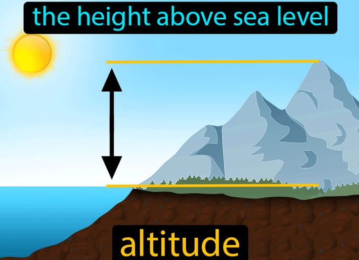
Imagine standing at the base of a towering mountain and looking up at its snow-capped peak. Or consider a pilot adjusting the altitude of an aircraft to optimize fuel efficiency and ensure safety during flight. These scenarios, though vastly different, are both governed by the concept of altitude. But what is altitude? In simple terms, altitude is the vertical distance of an object or point in relation to a specific reference level—most commonly, sea level. It’s an essential measure that influences our environment, technology, and even our health.
An Intriguing Fact
Did you know that atmospheric pressure decreases by about 12% for every 1,000 meters (approximately 3,280 feet) increase in altitude? This dramatic change in pressure not only affects the weather and climate but also has a profound impact on human physiology. Understanding what is altitude is fundamental to many fields, from predicting weather patterns to ensuring the safety of aircraft and high-altitude mountaineering.
What This Post Will Cover and Why It Matters
In this post, we will explore:
- Definition and Core Characteristics:
We’ll answer the question, “what is altitude?” by providing a clear, concise definition and outlining its fundamental properties. - Historical and Contextual Background:
Discover the origins and evolution of altitude measurement—from ancient observations to the invention of modern altimeters—and learn about key milestones in our understanding of vertical distance. - In-Depth Exploration:
We’ll break down the different types of altitude (true, indicated, pressure, density, absolute, and height above ground level), explain how altitude is measured, and illustrate its effects on atmospheric conditions. Real-world examples, case studies, and scenarios will help you see how altitude is applied and observed. - Importance, Applications, and Benefits:
Learn why altitude is significant in fields such as aviation, meteorology, geography, environmental science, sports, and even in business and technology. We’ll highlight its practical benefits and common uses, and explain how an understanding of altitude can enhance decision-making and innovation. - Addressing Common Misconceptions and FAQs:
We’ll clear up common misunderstandings about altitude with a helpful Q&A section, ensuring that you leave with a clear and accurate picture of the concept. - Modern Relevance and Current Trends:
Explore how advancements in technology and research are reshaping our understanding of altitude. We’ll discuss new developments in altimetry, the impact of climate change on altitude measurements, and the latest trends in low-pressure studies. - Conclusion and Call-to-Action:
A succinct summary of the key points, along with a call-to-action encouraging you to explore further, share your insights, and apply this knowledge in your daily life.
Understanding what is altitude is critical because it affects everything from weather forecasting and flight safety to our health and environmental conservation. So, whether you’re intrigued by the physics of our atmosphere or need to grasp altitude for practical applications, let’s dive into the fascinating world of vertical measurement.
What Is Altitude? A Straightforward Definition
Defining Altitude
At its most basic, what is altitude? Altitude is the vertical distance of an object or point relative to a fixed reference level, typically mean sea level. It is a measure used to describe the elevation of geographical features, aircraft, and even the position of satellites in orbit.
For example:
- Geographical Altitude:
The altitude of a mountain is the height of its summit above sea level. - Aviation Altitude:
The altitude of an airplane refers to its height above sea level or above ground level, depending on the context. - Space Applications:
For satellites and spacecraft, altitude is measured relative to Earth’s surface or its center.
Essential Characteristics of Altitude
To understand what is altitude fully, consider the following defining attributes:
- Vertical Measurement:
Altitude is exclusively concerned with vertical distance—it measures how high something is. - Reference Level:
Altitude is measured relative to a defined baseline, most commonly mean sea level (MSL). In some cases, altitude may be measured relative to ground level (AGL) or another specific reference point. - Units of Measurement:
Altitude is typically measured in meters or feet, depending on regional conventions. For scientific purposes, meters are more commonly used. - Dynamic and Static Applications:
Altitude can be used to describe fixed geographical features (static) as well as the changing height of moving objects like aircraft or balloons (dynamic). - Impact on Environmental Conditions:
Changes in altitude are associated with changes in atmospheric pressure, temperature, and oxygen levels, which have significant effects on weather patterns and human physiology.
These characteristics reveal that what is altitude is not just a simple height measurement—it is a complex, dynamic concept that plays a crucial role in science, technology, and everyday life.
Historical and Contextual Background
The Evolution of Altitude Measurement
The concept of altitude has fascinated humans for centuries. Its measurement has evolved from rudimentary methods to sophisticated technological systems that underpin modern navigation, meteorology, and aerospace engineering.
Ancient and Medieval Methods
- Early Observations:
Ancient civilizations made basic estimations of altitude using simple tools and observations. For instance, ancient Greeks used the angle of the sun and shadows to estimate the height of structures and geographical features. - Medieval Techniques:
During the Middle Ages, scholars and explorers relied on rudimentary instruments such as the astrolabe to determine altitude for navigation and mapping. Although these methods lacked precision, they laid the groundwork for future advancements.
The Advent of Modern Altimetry
- Invention of the Barometric Altimeter:
In the 19th century, the invention of the barometric altimeter revolutionized altitude measurement. This instrument uses changes in atmospheric pressure to determine altitude, providing much greater accuracy for aviation and meteorology. - Development of Radar and Laser Altimetry:
The 20th century saw further advancements with the introduction of radar altimeters and, later, laser altimeters. These technologies allowed for precise altitude measurements in various applications, including spacecraft landing systems and terrain mapping. - Digital and Satellite Technologies:
Today, GPS and other satellite-based systems have transformed altitude measurement. Modern digital altimeters integrate data from multiple sources, providing real-time, highly accurate altitude information for everything from aviation to outdoor recreation.
Notable Historical Anecdotes
- The Wright Brothers and Flight:
Early aviators like the Wright Brothers relied on primitive altitude measurements to navigate their first flights. Their successes and challenges in controlling altitude paved the way for the sophisticated systems used in aviation today. - Space Exploration Milestones:
The successful landing of spacecraft on the Moon required extremely precise altitude data. The advancements in altimetry developed during the space race have had lasting impacts on both space exploration and Earth-based applications. - Meteorological Breakthroughs:
The development of reliable altimeters greatly improved weather forecasting. Understanding the relationship between altitude and atmospheric conditions has been critical in predicting storms, turbulence, and climate patterns.
This historical journey illustrates that what is altitude is a concept with deep roots in human curiosity and ingenuity, evolving from simple observations to the cutting-edge technology that supports modern life.
In-Depth Exploration: Types, Attributes, and Categories of Altitude
To truly understand what is altitude, we must examine its various forms, how it is measured, and its applications across different fields.
1. Types of Altitude
True Altitude
- Definition:
True altitude is the actual vertical distance above mean sea level (MSL). It represents the real height of an object or point relative to the average level of the ocean’s surface. - Usage:
This measure is crucial in aviation and geography, where accurate height information is needed.
Indicated Altitude
- Definition:
Indicated altitude is the altitude shown on an aircraft’s altimeter, which is calibrated to the local barometric pressure. It may differ from true altitude if the atmospheric pressure varies from standard conditions. - Usage:
Pilots use indicated altitude for navigation and to maintain safe separation from obstacles.
Pressure Altitude
- Definition:
Pressure altitude is the altitude in the International Standard Atmosphere (ISA) that corresponds to a given atmospheric pressure. It is used in performance calculations for aircraft. - Usage:
It provides a consistent reference for comparing aircraft performance regardless of current weather conditions.
Density Altitude
- Definition:
Density altitude is the pressure altitude corrected for non-standard temperature. It reflects the “effective” altitude at which the air density matches the current conditions. - Usage:
It is an important factor in aircraft performance, affecting engine power, lift, and handling.
Absolute Altitude
- Definition:
Absolute altitude is the vertical distance above the ground level, as opposed to above sea level. - Usage:
This measurement is critical for activities such as mountain climbing, where the terrain varies significantly.
2. How Altitude Is Measured
Barometric Altimeters
- Working Principle:
Barometric altimeters measure altitude by comparing the current atmospheric pressure with a reference pressure at sea level. As altitude increases, atmospheric pressure decreases. - Applications:
Widely used in aviation, these altimeters are crucial for ensuring safe flight levels and navigation.
Radar Altimeters
- Working Principle:
Radar altimeters use radio waves to measure the distance between an aircraft and the ground directly beneath it. This method is highly accurate, particularly at low altitudes. - Applications:
They are used during landing approaches and in terrain-following systems to provide real-time altitude data.
Laser Altimeters
- Working Principle:
Laser altimeters (lidar) use laser beams to measure the distance to the ground. They are highly precise and are increasingly used in mapping and remote sensing. - Applications:
These systems are employed in geospatial surveys, environmental monitoring, and even in spacecraft for planetary exploration.
Satellite-Based Measurements (GPS)
- Working Principle:
Modern Global Positioning System (GPS) devices calculate altitude by triangulating signals from multiple satellites. - Applications:
GPS altitude is used in navigation, hiking, aviation, and numerous other fields, providing a quick and accurate measure of elevation.
3. Real-World Examples and Case Studies
Case Study 1: Altitude in Aviation
- Overview:
In aviation, accurate altitude measurements are critical for flight safety. Aircraft rely on various altitude data—indicated, pressure, and density altitudes—to navigate, avoid obstacles, and maintain proper flight levels. - Example:
A pilot flying over mountainous terrain must use radar altimetry and GPS data to adjust the flight path, ensuring a safe altitude above the ground.
Case Study 2: Altitude and Weather Patterns
- Overview:
Meteorologists study altitude to understand atmospheric layers and predict weather patterns. Temperature, pressure, and humidity vary with altitude, influencing cloud formation, precipitation, and wind patterns. - Example:
Weather balloons equipped with sensors measure atmospheric conditions at various altitudes, providing data that helps forecast weather and track climate changes.
Case Study 3: Impact of Altitude on Human Physiology
- Overview:
At high altitudes, the reduced oxygen levels and lower atmospheric pressure can affect human health, leading to conditions such as altitude sickness. - Example:
Mountaineers and high-altitude trekkers must acclimatize gradually to avoid the adverse effects of high altitude. Research into altitude physiology has improved safety guidelines for mountain expeditions.
Case Study 4: Altitude in Environmental and Geographical Research
- Overview:
Researchers use altitude measurements to study ecosystems, terrain, and environmental changes. Altitude data is critical in understanding how different species adapt to varying conditions and in modeling climate change impacts. - Example:
In the Andes, scientists study how plant and animal species vary with altitude, providing insights into biodiversity and the effects of climate change on ecosystems.
Importance, Applications, and Benefits of Understanding What Is Altitude
Understanding what is altitude is crucial because it has a wide range of applications and benefits across many domains:
1. Scientific and Environmental Research
- Meteorology and Climate Science:
Altitude is a key variable in weather forecasting and climate studies. It influences temperature, atmospheric pressure, and moisture levels, all of which are critical for accurate models and predictions. - Ecological Studies:
The altitude of a habitat affects the types of organisms that can survive there. Researchers use altitude data to study biodiversity, migration patterns, and the impacts of climate change on ecosystems.
2. Aviation and Aerospace
- Flight Safety:
Accurate altitude measurements are essential for safe aircraft navigation. Pilots rely on altimeters to maintain safe distances from the ground and other aircraft. - Performance Optimization:
Understanding various altitude measurements (pressure, density, true altitude) helps optimize aircraft performance, ensuring efficient fuel usage and safe operations under varying atmospheric conditions. - Space Exploration:
For spacecraft and satellites, altitude data is critical in orbital mechanics, ensuring proper positioning and safe re-entry into Earth’s atmosphere.
3. Engineering and Technology
- Infrastructure Design:
Engineers consider altitude when designing structures, transportation systems, and communication networks. Altitude impacts factors such as air density and wind loads, which are essential for building safety and efficiency. - Renewable Energy Systems:
In wind energy and solar power installations, altitude affects energy production. For example, wind turbines often operate more efficiently at higher altitudes where wind speeds are greater.
4. Health and Human Physiology
- Altitude Sickness Prevention:
Understanding how altitude affects oxygen levels and atmospheric pressure is crucial for preventing altitude sickness in mountaineers, pilots, and travelers. Gradual acclimatization protocols and medical interventions are developed based on altitude research. - Athletic Training:
Some athletes train at high altitudes to improve their performance by increasing their body’s efficiency in oxygen utilization. This practice, known as altitude training, relies on a deep understanding of altitude’s physiological effects.
5. Everyday Applications and Lifestyle
- Outdoor Recreation:
Whether you’re hiking, skiing, or mountain biking, altitude plays a significant role in planning and safety. Understanding altitude can help you prepare for changes in weather, oxygen levels, and physical exertion. - Geographical Awareness:
Altitude is a key factor in geography and topography. It influences the climate, vegetation, and natural resources of a region, which in turn affect agriculture, urban planning, and economic development. - Travel and Tourism:
Many tourist destinations are situated at high altitudes, and travelers benefit from understanding the effects of altitude on health and comfort. This knowledge can inform travel plans and improve the overall experience.
Addressing Common Misconceptions and FAQs
Despite its critical importance, there are several common misconceptions about what is altitude. Let’s address and clarify these with a Q&A section.
Misconception 1: Altitude Is the Same as Elevation
Myth:
Some people mistakenly use the terms “altitude” and “elevation” interchangeably.
Reality:
- Contextual Differences:
While both terms refer to vertical distance, “altitude” is often used in the context of aviation and atmospheric studies (measured from sea level or ground level), whereas “elevation” typically refers to the height of a geographic location above sea level. - Specific Applications:
The distinction is important in fields like aviation, where indicated altitude and true altitude have specific meanings that differ from general geographical elevation.
Misconception 2: Higher Altitude Always Means Colder Temperature
Myth:
Many assume that the temperature drops uniformly as altitude increases.
Reality:
- General Trend with Exceptions:
Generally, temperature decreases with altitude due to lower atmospheric pressure. However, factors such as inversion layers, regional weather patterns, and local geography can cause variations in this trend. - Complex Atmospheric Interactions:
The relationship between altitude and temperature is influenced by multiple factors, including humidity, air mass characteristics, and solar radiation, making it a more complex interaction than a simple linear drop.
Misconception 3: Altitude Is Only Relevant for Pilots and Mountaineers
Myth:
Some believe that altitude is a niche concept, only applicable to those in aviation or extreme sports.
Reality:
- Broad Relevance:
Altitude affects many aspects of daily life, including weather forecasting, environmental planning, agriculture, and urban development. Its impact extends to diverse fields such as renewable energy, health, and even economic planning. - Interdisciplinary Importance:
Understanding altitude is fundamental in science and technology, influencing everything from climate models and satellite communications to the design of high-altitude structures and vehicles.
Frequently Asked Questions (FAQs)
Q: What is altitude?
A: Altitude is the vertical distance of an object or point relative to a fixed reference level, usually mean sea level. It is used to describe the height of geographic features, aircraft, and other objects.Q: How is altitude measured?
A: Altitude is measured using various instruments such as barometric altimeters (which gauge atmospheric pressure), radar altimeters (which use radio waves), laser altimeters (lidar), and satellite-based systems like GPS.Q: What is the difference between true altitude and indicated altitude?
A: True altitude is the actual height above sea level, while indicated altitude is what is shown on an aircraft’s altimeter, which can vary due to changes in atmospheric pressure.Q: Why does altitude affect temperature?
A: As altitude increases, atmospheric pressure decreases, which generally leads to a reduction in temperature. However, other factors such as weather patterns and local geography can influence this relationship.Q: How can understanding altitude help in everyday life?
A: Knowing about altitude is important for activities such as hiking, planning air travel, understanding weather forecasts, and even for designing buildings and infrastructure in areas with varied topography.
Modern Relevance and Current Trends
Altitude in Today’s Global and Technological Landscape
In today’s interconnected world, the concept of altitude continues to play a critical role in various fields, driving innovation and informing decision-making in both science and everyday life.
Technological Innovations and Digital Integration
- Advanced Altimetry Systems:
Modern technology has led to the development of highly accurate altimetry systems that combine barometric, radar, and satellite data. These systems are essential in aviation, meteorology, and even autonomous vehicles. - Smart Devices and Wearables:
Many smartphones, smartwatches, and fitness trackers now include altimeters that provide real-time altitude data, helping users track their physical activities and monitor health metrics. - Remote Sensing and GIS:
Geographic Information Systems (GIS) and remote sensing technologies rely on precise altitude data to map terrains, analyze environmental changes, and support urban planning.
Renewable Energy and Environmental Applications
- Wind and Solar Energy:
Altitude plays a significant role in renewable energy generation. For instance, wind speeds generally increase at higher altitudes, which can enhance the efficiency of wind turbines. Similarly, altitude can affect solar irradiance, influencing the performance of solar panels. - Climate Research:
Altitude data is crucial for understanding atmospheric processes and climate patterns. Researchers use altitude measurements to model weather systems, study pollution dispersion, and assess the impacts of climate change on different ecosystems. - Agricultural Planning:
Farmers and agricultural planners use altitude data to optimize crop selection and manage water resources, ensuring sustainable agricultural practices in regions with varying elevations.
Global and Cultural Implications
- Urban Development and Infrastructure:
In mountainous regions, altitude is a critical factor in urban planning and infrastructure development. Engineers and architects design buildings, roads, and bridges to withstand the challenges posed by high-altitude environments. - Tourism and Recreation:
High-altitude destinations attract tourists for activities such as skiing, mountaineering, and hiking. Understanding altitude helps in preparing for these activities and ensuring safety in extreme environments. - Economic Impact:
Regions with significant altitude variations often have unique economic challenges and opportunities. For example, high-altitude areas may require specialized infrastructure and energy solutions, influencing regional development and investment.
Educational and Research Advances
- Interactive Learning Platforms:
Digital tools and online courses now offer interactive modules on altitude measurement and its applications. These platforms make it easier for students and enthusiasts to learn about altitude through simulations and real-time data. - Interdisciplinary Studies:
The study of altitude bridges multiple disciplines, including physics, geography, environmental science, and engineering. This interdisciplinary approach fosters a holistic understanding of how altitude influences our world. - Public Outreach:
Science museums, documentaries, and public lectures frequently feature topics related to altitude, helping to increase public awareness and appreciation of this fundamental concept.
Conclusion: The Elevating Importance of Altitude
In exploring what is altitude, we have uncovered a concept that is both fundamental and far-reaching. Altitude, defined as the vertical distance from a reference point (usually sea level), is a critical parameter that influences weather, environmental conditions, human physiology, and technological applications. From the early days of barometric altimeters to modern GPS and digital sensors, our understanding of altitude has evolved dramatically, driving innovations that shape our daily lives and global infrastructure.
Key Takeaways
- Definition and Core Concepts:
Altitude is the measure of vertical distance from a specific reference point, typically mean sea level. It plays a vital role in various fields by influencing atmospheric pressure, temperature, and the performance of engineered systems. - Historical Evolution:
The concept of altitude has a rich history, evolving from early observational methods to sophisticated digital measurement systems. Key milestones include the invention of the barometric altimeter, the standardization of altitude scales, and the integration of satellite technology. - Diverse Applications:
Altitude is integral to aviation, meteorology, environmental science, urban planning, renewable energy, and even sports. Its applications are broad and impact many aspects of modern life. - Modern Relevance:
In today’s digital and globalized world, advancements in technology continue to refine our ability to measure and utilize altitude, driving innovations in smart infrastructure, renewable energy, and scientific research. - Practical Benefits:
A solid understanding of altitude enhances decision-making in everything from planning safe air travel and outdoor activities to designing efficient power grids and sustainable urban environments.
Call-to-Action
Now that you have a comprehensive understanding of what is altitude, here’s how you can put this knowledge into practice:
- Reflect on Your Environment:
Whether you’re traveling, hiking, or planning a project, consider how altitude impacts the conditions around you. Use altitude data to inform your decisions and enhance your safety and comfort. - Engage in Further Learning:
Dive deeper into the science of altitude by exploring resources such as the National Oceanic and Atmospheric Administration (NOAA) and the U.S. Geological Survey (USGS). These organizations provide up-to-date research and data on atmospheric and geological measurements. - Share Your Insights:
Join the conversation by commenting below. How has your understanding of altitude influenced your travel plans, outdoor activities, or professional projects? Share your experiences using hashtags like #WhatIsAltitude and #AltitudeMatters on social media. - Spread the Knowledge:
If you found this post informative, please share it with friends, colleagues, and anyone interested in learning about the critical role of altitude in our world. Your insights can help others appreciate the importance of this fundamental concept. - Apply in Your Professional or Academic Life:
Whether you’re an engineer, environmental scientist, educator, or policy maker, use your understanding of altitude to drive innovation, improve safety protocols, and contribute to more sustainable practices.
Final Thoughts
Understanding what is altitude is a gateway to appreciating one of the most fundamental measurements in science. Altitude is not merely a number on a chart—it is a dynamic and multifaceted concept that influences weather, climate, technology, and human life. As you continue to explore the world around you, remember that every peak, every valley, and every flight of an airplane is defined by its altitude. Embrace the knowledge of altitude, let it inform your decisions, and appreciate the intricate ways in which this measurement shapes our environment and our lives.
Thank you for joining us on this in-depth exploration of what is altitude. We hope this guide has enriched your understanding and sparked your curiosity about the vertical dimensions that govern our world. Happy exploring, and may your journey into the realm of altitude lead you to new heights of discovery and innovation!