
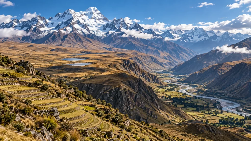
The Andes Mountains form a long, varied chain along the western side of South America. They are not one uniform wall of snow or one historical civilization. The range includes tropical cloud forests, dry intermontane valleys, high grasslands, volcanic zones, glaciers, and densely settled cities. Its geography helps explain where people farmed, how communities exchanged goods, why the Inca built an immense road network, and why earthquakes and changing water supplies matter today. This guide connects the physical landscape with human history while distinguishing well-supported facts from familiar oversimplifications.
Where are the Andes Mountains?
The Andes run broadly north to south beside the Pacific margin of South America, through or along parts of Venezuela, Colombia, Ecuador, Peru, Bolivia, Chile, and Argentina. The often-cited length of roughly 7,000 kilometers is an approximation: a mountain system has branches and transition zones rather than a perfectly sharp start and end. At many latitudes, parallel ranges enclose elevated basins or valleys. A map therefore shows not a single narrow ridge but a complex system whose width and relief vary markedly from place to place.
Aconcagua in Argentina is the highest summit of the Andes and of the Americas, at nearly 7,000 meters above sea level. Height alone, however, does not describe the range. A traveler might encounter humid slopes in Colombia, an arid plateau in the central Andes, and glaciated peaks farther south. The nearby coast, latitude, elevation, prevailing winds, and rain shadows all shape local conditions. Avoid treating a description of one valley as if it applied to the entire continent.
Several major regions make the diversity easier to visualize. The northern Andes include mountain branches in Colombia and Ecuador and many volcanic landscapes. In the central Andes, parts of Peru, Bolivia, northern Chile, and northwestern Argentina contain high plateaus and deep valleys. The southern Andes extend into Chile and Argentina, where temperate forests, lakes, ice fields, and mountains occur in different combinations. These are broad geographical labels, not rigid ecological borders. A person can travel only a short horizontal distance yet cross a large vertical change in climate.
How did the Andes form?
The central geological process is plate convergence. Along much of South America’s Pacific edge, the oceanic Nazca Plate descends beneath the continental South American Plate. Compression, crustal deformation, uplift, and volcanism have helped build the mountain system over millions of years. The U.S. Geological Survey’s seismotectonic account connects subduction with Andean uplift and the active volcanic chain. That mechanism is more precise than saying that two continents simply collided.
Mountain building is neither a single event nor a process that proceeds identically along every segment. Rocks have been folded, faulted, intruded, eroded, and elevated at different times. Some parts of the margin produce prominent volcanic arcs; others have fewer active volcanoes because the geometry of the descending slab differs. Rivers and glaciers carve the uplifted terrain while the tectonic system continues to create relief. The visible landforms are consequently the result of both construction and erosion.
The same plate boundary produces hazards. Stress can accumulate on faults and then be released as earthquakes; subduction and rising magma are associated with volcanoes in many parts of the range. Landslides can follow heavy rain, earthquakes, or slope disturbance. None of this means that every Andean town faces the same danger. Local geology, building quality, exposure, and preparedness affect risk. For a geography answer, distinguish the natural process from the human vulnerability that can turn a hazard into a disaster.
Elevation, climate, and ecosystems
Elevation changes temperature, air pressure, and the length of the growing season. As air rises over mountains it can cool and release precipitation, while the other side of a ridge may be much drier. Latitude also matters: tropical mountains near the equator do not follow the same seasonal pattern as the southern Andes. This is why fixed altitude bands with universal crop lists are misleading. An elevation suitable for a crop in one valley may be too dry, too shaded, or too cold in another.
Lower slopes may contain warm forests or cultivated valleys. Higher up, cloud forests occur where moist air and mountain relief interact, and high-elevation grasslands support distinctive plants and grazing. The puna and páramo are not interchangeable labels for all high places: they refer to different regional highland environments. Beyond the upper limits of vegetation, bare rock, snow, and ice dominate some peaks. Human settlements exist across many zones, but their livelihoods depend on local water, soils, routes, and social arrangements as much as temperature.
The central Andes also include the Altiplano, a vast high plateau associated especially with Bolivia and Peru. Lake Titicaca lies within this highland setting. A plateau can make settlement, travel, and agriculture possible on a scale different from that of a narrow mountain slope, yet altitude still brings cold nights and difficult growing conditions. Students should be able to explain both constraint and opportunity: mountain terrain is challenging, but it also offers ecological diversity and resources that people learned to use.
Glaciers store water in some Andean basins and influence seasonal runoff. Their role differs between catchments, so a statement such as “every Andean city depends on glacier melt” would be inaccurate. UNESCO’s Andean Glacier and Water Atlas documents retreat and its implications for water management. Shrinking glaciers can alter dry-season supply, expose unstable slopes, and contribute to the growth of glacial lakes. Water planning must also account for rainfall, groundwater, land use, and demand.
Why the mountains mattered before the Inca
Andean history did not begin with the Inca Empire. Communities developed farming, herding, exchange networks, ceremonial centers, and political systems long before Inca expansion. Different societies occupied the coast, highlands, and eastern slopes, adapting to their own environments. Geography influenced those choices, but it did not dictate a single inevitable path. The existence of varied societies in comparable terrain is evidence that institutions, knowledge, and relationships also mattered.
One important historical pattern was the use of several ecological zones. A highland community might have access, directly or through exchange, to products grown at different elevations. Potatoes adapted to cold highlands, maize from suitable valleys, and other foods or materials from lower environments did not all come from one field. This does not mean every household owned land in every zone. It means that movement, reciprocal obligations, local specialization, and political organization could connect contrasting environments.
Andean peoples bred and maintained remarkable crop diversity. The Food and Agriculture Organization’s account of native potatoes describes highland varieties in Peru and Bolivia and their adaptation to demanding conditions. The diversity is a continuing achievement of farmers, not merely an archaeological curiosity. It can spread risk when weather, pests, or soils differ from plot to plot. Describing “the potato” as a single uniform crop misses this history of selection and stewardship.
Camelids such as llamas and alpacas were important for transport, fiber, and other uses in many regions. They were not a universal substitute for wheeled carts or draft horses, and their role varied by place and period. Mountain passes, steep slopes, and long distances shaped the movement of people and goods. An account of Andean adaptation should consider these animals alongside pathways, storage, irrigation, terraces, and community labor, rather than crediting any one invention with solving every challenge.
Terraces, water, and highland agriculture
Terraces create flatter working surfaces on slopes and can help manage soil and water when they are well designed and maintained. Retaining walls, drainage layers, and irrigation channels differ among sites. A terrace is not automatically fertile: farmers must manage soil, water, crops, and repairs. On a steep hillside, the value of a terrace may include limiting erosion and making cultivation more practical. The effect cannot be summarized as simply “terraces made the mountains farmable,” because people also farmed valley floors and plateaus.
Imagine two fields receiving the same rain. On an unprotected steep slope, water may run downhill quickly and carry topsoil. A carefully maintained terrace interrupts that flow and provides a more stable surface, but a blocked drain or damaged wall can create new problems. This worked example shows why engineering and ongoing collective care both matter. It also explains why a photographed terrace is evidence of labor and environmental knowledge, not evidence that every harvest was abundant.
Farmers combined crops and locations to manage uncertainty. A cold snap might damage one variety or elevation more than another. Planting a range of native potatoes or using fields across different microclimates could reduce exposure to one local failure. The FAO’s account explains that highland crop diversity remains linked to cultural practice and the work of farming families. Modern farmers continue to adapt; it is misleading to portray Andean agriculture as a technique frozen in the fifteenth century.
Irrigation was crucial in some valleys, especially where rainfall alone was unreliable. Channels required knowledge of slope and flow as well as rules governing access and maintenance. Yet the word “irrigation” should not erase regional variation: in a wet highland environment, drainage may be as important as delivery of water. In a dry valley, secure access to a canal might affect who could cultivate land. Geography and social organization interacted, and both belong in a complete historical explanation.
The Inca Empire and a difficult landscape
The Inca state grew from the Cusco region and expanded dramatically in the fifteenth and early sixteenth centuries. It governed a geographically varied territory that included mountains, valleys, deserts, and coasts. A useful study question is not “How did the Andes create the Inca?” but “How did Inca rulers use institutions and infrastructure to govern across Andean environments?” The empire drew on earlier regional knowledge and roads, and it incorporated people with distinct languages and customs.
Roads were a central part of that answer. UNESCO describes the Qhapaq Ñan as an extensive communication, trade, and defense network reaching approximately 30,000 kilometers, built over centuries and partly on pre-Inca infrastructure. Road surfaces, stairs, bridges, drainage, and waystations responded to local terrain. The network linked administrative and ceremonial centers with productive areas. It did not make mountains disappear; it organized movement through them.
Runners could convey messages along roads, while officials, armies, and laborers used routes for different purposes. Storage facilities helped move or hold supplies. These systems made long-distance governance more feasible, although travel times and control still depended on weather, terrain, people, and political cooperation. Avoid the textbook shortcut that roads were built only for trade. They also supported military logistics, state administration, communication, and integration of diverse territories.
Inca administrators used khipu, arrangements of knotted cords, for record keeping. Scholars continue to investigate the range of information these objects encoded, so it is safer to describe their documented administrative significance than to claim that every knot has a fully deciphered meaning. Labor obligations often discussed under the term mit’a supplied work for state projects, but their operation and consequences were embedded in unequal political relationships. A road or terrace can be an engineering achievement while its construction also raises questions about power and obligation.
Machu Picchu offers a vivid example of architecture fitted to a steep Andean setting. UNESCO describes its fifteenth-century structures, terraces, and integration with the surrounding landscape. The site’s precise role remains debated in some respects; a confident single-purpose label would overstate the evidence. It is useful because it joins several themes on one ridge: building techniques, drainage and land use, political or ceremonial significance, and the choices involved in protecting a landscape that is both cultural and natural heritage.
The Inca should also be placed in time. A page about the Andes covers geological time, millennia of farming and earlier states, a comparatively short period of imperial expansion, the Spanish conquest, and continuing Indigenous communities. These are not interchangeable chapters. The Andes did not “decline” when the Inca state fell. Colonial violence and disease transformed societies, but Andean languages, agricultural knowledge, and cultural practices persisted and changed. Today millions of people live in and around the mountains.
From conquest to the present
Spanish conquest in the sixteenth century involved warfare, alliances, epidemic disease, and conflict within the Inca polity. Rugged terrain shaped campaigns and resistance, but it was not a simple defensive shield that guaranteed survival. Nor can the outcome be reduced to a single technological advantage. Historical explanations work best when they combine political divisions, disease, military events, and the choices of Indigenous and Spanish actors. A map of passes and centers can help, but geography alone does not settle the question.
Colonial authorities altered landholding, labor systems, mining, religion, and routes of exchange. Some earlier practices continued in modified forms. The distinction between Inca mit’a and colonial forced-labor arrangements deserves particular care: similar names should not obscure changed political conditions and coercion. A student comparing periods should ask who demanded labor, for what purpose, under what rules, and with what effects on communities. This makes the Andes a case study in both continuity and change.
Present-day Andean life is not a relic of the empire. Large cities, farms, mines, protected areas, roads, tourism, and Indigenous territories coexist across the range. Quechua and Aymara languages, among many others, are living languages. Indigenous people are not one undifferentiated group, and their experiences vary by country and community. Land and water decisions are often contemporary political questions involving livelihoods, conservation, development, and rights.
Tourism can bring income and attention to heritage, but heavy use may strain paths, water, and sites. Conservation must also consider local people rather than treating inhabited landscapes as empty scenery. UNESCO’s description of the Historic Sanctuary of Machu Picchu emphasizes its intertwined cultural and natural significance. That is a useful model for reading other Andean landscapes: a terrace, forest, or road can be both an ecological feature and part of a long human story.
Contemporary environmental questions
Mountain water is a practical concern because rainfall, snow, ice, soil, and groundwater feed rivers used downstream. A warmer climate can change the timing and amount of runoff, especially where glaciers are retreating. The effects are not identical in every basin: a small glacier-dependent catchment differs from a large river system dominated by rainfall. Students should state the scale and place when making a claim about water security. UNESCO’s glacier atlas provides a starting point for evidence rather than a license to generalize.
Glacial lakes can grow as ice retreats; in some settings an unstable natural dam can fail, causing dangerous flooding. Elsewhere, prolonged drought or competition for water may be the more immediate issue. Disaster risk depends on where people live, monitoring and warning capacity, infrastructure, and response plans. The same physical change can have very different human outcomes. This distinction between environmental process and social vulnerability is a core geography skill.
Highland biodiversity also matters. Protected areas conserve habitat and water sources, but conservation choices may affect farming and grazing. UNESCO identifies Huascarán National Park and its wider biosphere reserve as a landscape with tropical glaciers, lakes, high plateaus, and varied vegetation. A single protected area cannot represent the full Andes, yet it demonstrates why ecology should be considered alongside geological and political history.
Mining and energy development add another layer. The range contains valuable mineral resources, and projects can create jobs and public revenue. They can also raise concerns about water use, pollution, displacement, and who receives the benefits. There is no one mountain-wide answer. A careful analysis names the local project, its evidence, affected communities, environmental rules, and alternatives. This helps avoid the equally simplistic claims that all extraction is harmless or that all Andean communities hold one view.
How to analyze the Andes in AP World History and geography
The current AP World History: Modern framework begins in 1200 CE and asks students to connect developments across regions and themes. Geological formation occurred long before that period; it is background, not an AP World event dated 1200–1450. The Inca case can illustrate state building, human-environment interaction, and technology, while later conquest and colonial rule illustrate continuity and change. Keep the time period of a prompt in view before selecting evidence.
For a causation prompt, build a chain rather than writing “mountains caused terraces.” First identify an environmental condition such as steep slopes and varied elevations. Then identify a human response, for example terraces, crop diversity, or roads. Next explain the institution that made maintenance or coordination possible. Finally, state the outcome with a limit: roads helped administrative integration, but they did not guarantee political stability. Each link of the chain can be supported by a specific example.
For comparison, set the Andes beside another environment without suggesting that similar terrain always creates similar societies. Compare how Andean communities used elevation and road networks with how a river-valley state managed water or a maritime state used sea routes. Specify what is comparable—transport costs, food production, administrative reach—and what differs, including political institutions and available technologies. This produces analysis rather than a catalogue of scenic features.
For continuity and change, begin before the Inca and continue after the conquest. Some farming and community practices persisted, while political authority, labor demands, and wider economic connections changed. The answer should avoid a story in which a civilization appears, disappears, and leaves an empty landscape. Modern highland farming and living Indigenous languages are evidence that history continued, even though it did not remain unchanged.
A physical map can strengthen each of these arguments if it is read carefully. First locate the Pacific coast and the main north-south mountain trend. Then identify plateaus, passes, valleys, and major river directions. Compare those features with a historical map of settlements, roads, or political centers. Overlap can suggest a useful question, such as why a route follows a valley, but it does not prove that terrain alone determined the route. Ask when each map was made, what its symbols mean, and whether its scale hides smaller paths or communities.
Maps can also distort perception. A small-scale continental map may make the Andes look like one continuous line and hide the great distance between a coastal desert and a humid eastern slope. A modern national boundary may cut across an older cultural region; it cannot be projected backward as if it governed fifteenth-century movement. In an exam response, identify the specific region you are discussing before describing “the Andes.” That habit makes examples more defensible and prevents a fact about Peru from being casually applied to Colombia or Patagonia.
Worked examples and common misconceptions
Example: explain why a road mattered. A mountain pass is difficult to cross and can isolate settlements. A maintained road with bridges and waystations lowers some of the cost of moving messengers, goods, and officials. A state can then communicate and provision distant regions more reliably. The road is not merely a line on a map; it depends on labor, security, and local knowledge. UNESCO’s Qhapaq Ñan record provides the concrete evidence for this argument.
Example: interpret a photograph of terraces. Identify the modified slope, walls, and possible drainage or irrigation features. Infer that people invested work to manage a challenging hillside. Do not infer the date, crop, yield, or ruler from appearance alone. Seek a caption, archaeological context, or agricultural study. This separates observation from interpretation, a skill useful beyond Andean history.
Misconception: the Andes are always cold. Temperatures tend to fall with height, but low valleys and eastern slopes can be warm. Latitude, exposure, rainfall, and season produce major differences. Misconception: the Inca invented every Andean technique. They expanded and coordinated earlier practices and infrastructure. Misconception: mountains made contact impossible. People crossed them and built networks; terrain affected the costs and routes of connection rather than preventing it entirely.
Misconception: the Andes and the Inca Empire are synonymous. The range spans seven modern countries and a far longer time than one state. Misconception: every highland field was terraced. Valleys, plateaus, and different slopes supported varied agricultural methods. Misconception: a glacier’s retreat has the same effect everywhere. Basin size, rainfall, storage, and water demand matter. Recognizing these limits makes an answer more accurate, not less confident.
Study questions with model reasoning
How did elevation influence agriculture? Different elevations create different temperatures and growing conditions. Andean farmers selected crops and varieties suited to local environments and linked production across zones through movement and exchange. Terraces and water management could make particular slopes more usable. The strongest answer gives a crop example, such as native potatoes in highland areas, while noting that altitude alone does not determine yield.
How did the Inca govern a varied territory? They used roads, bridges, messengers, storage, administrative records, labor obligations, and political power to connect regions. The Qhapaq Ñan is evidence of infrastructure adapted to extreme terrain and older routes. A complete answer also notes that the empire incorporated diverse peoples and that institutions could face resistance or disruption. “They built roads” is a fact; explaining how roads supported communication and provisioning is the analysis.
Why is the Andes a useful case for human-environment interaction? Plate tectonics produced varied relief; climate and elevation produced distinct ecological opportunities and hazards. People responded with farming systems, transport networks, settlements, and governance. Their decisions also reshaped slopes and water systems. The relationship is two-way and changes over time. An answer that treats environment as destiny misses human agency; one that ignores terrain misses the constraints people worked with.
What evidence would challenge an over-simple claim? If someone argues that steep terrain prevented political integration, the existence of the Qhapaq Ñan and its connected centers is a counterexample. If someone argues that the Inca alone developed highland farming, evidence of earlier agriculture and continuing farmer-managed potato diversity complicates that story. A counterexample does not mean geography was irrelevant; it forces a more precise claim about where, when, and how a constraint was overcome. This habit of testing broad statements against evidence is useful in geography, history, and environmental studies alike.
Key terms to keep distinct
Subduction is the descent of one tectonic plate beneath another. Altiplano is a high plateau region of the central Andes. Terrace is a constructed level or gently sloping surface on a hillside, used for purposes including cultivation. Qhapaq Ñan names the extensive Andean road network associated with Inca administration and earlier infrastructure. Khipu refers to knotted-cord records. Mit’a is a labor-obligation term that must be interpreted in its historical setting.
For the wider AP World context, the site’s state-building in the Americas guide compares the Inca with other societies of the period. The 1450–1750 continuity-and-change lesson is a next step for analyzing the conquest and colonial era. These are complements to the geographical account here, not substitutes for local Andean evidence.
Conclusion
The Andes are a mountain system, a collection of ecosystems, and a setting for many continuing histories. Subduction helps explain the range’s relief and hazards. Elevation and rainfall create varied environments rather than one uniform climate. Andean farmers and states used crop diversity, terraces, water systems, roads, and institutions to live and govern across that terrain. The Inca are an important chapter, but neither the first nor the last. The best explanation names a place and period, connects environment to a specific human response, and checks where a generalization stops being true.