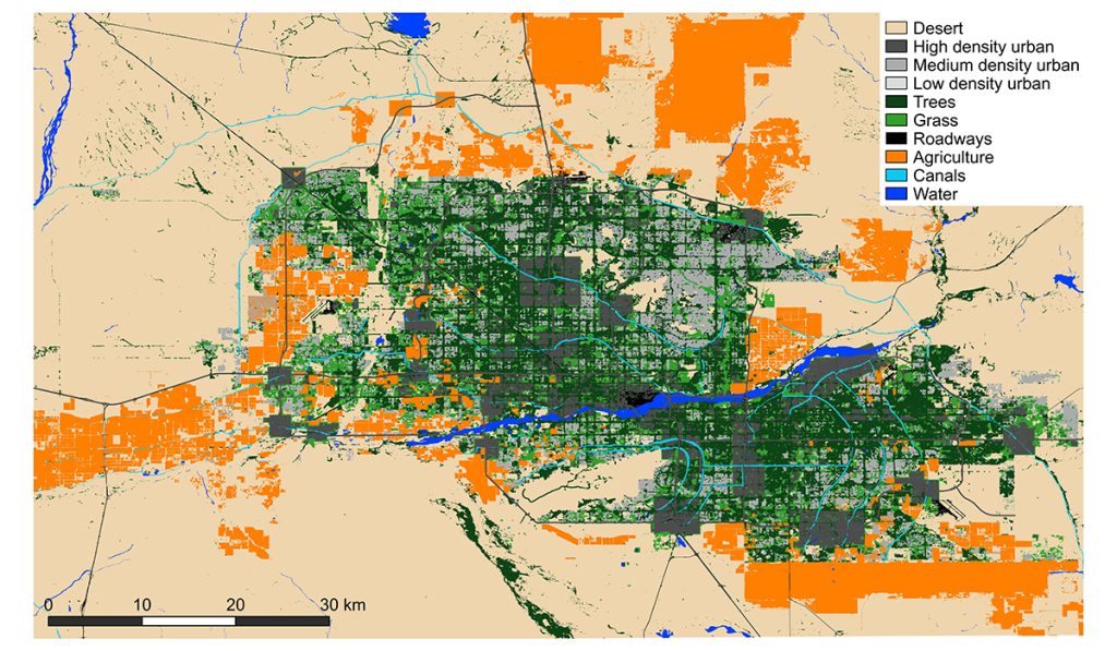
Density and Land Use

What is Population Density?
Population density measures the number of people living in a specific area, typically expressed as the number of individuals per square kilometer or square mile. It provides insights into how populations are distributed and concentrated within regions, influencing various aspects of society, economy, and politics.
Factors Influencing Population Density
Several factors can affect population density, including:
- Geography: Physical features like mountains, rivers, and climate can either attract or deter population settlements.
- Climate: Favorable climates support higher population densities, while harsh climates can limit habitation.
- Natural Resources: Availability of resources such as water, fertile land, and minerals can drive population concentration.
- Transportation Infrastructure: Efficient transport systems facilitate movement and economic activities, attracting more people.
- Economic Opportunities: Regions with abundant job opportunities tend to have higher population densities.
- Urbanization: Movement from rural to urban areas increases population density in cities.
Population density can fluctuate over time due to population growth, migration, and changes in urban development.
3 Methods of Measuring Population Density
Understanding population density involves various measurement methods, each providing unique perspectives on how populations interact with their environments.
Arithmetic Density
Arithmetic density is the simplest measure of population density, calculated by dividing the total population by the total land area.
Arithmetic Density=Total Land AreaTotal Population
- Pros:
- Simple and straightforward to calculate.
- Useful for broad comparisons between different regions or countries.
- Cons:
- Does not account for the distribution of population within the area.
- Can be misleading in regions with large uninhabitable areas.
Example: If a country has a population of 10 million and a land area of 100,000 square kilometers, its arithmetic density is 100 people per square kilometer.
Physiological Density
Physiological density measures the population relative to the amount of arable (farmable) land.
Physiological Density=Arable Land AreaTotal Population
Pros:
- Provides a better understanding of the pressure on productive land.
- Useful for assessing agricultural sustainability.
Cons:
- Requires accurate data on arable land, which can be difficult to obtain.
- Does not account for technological advancements in agriculture.
Example: If a region has a population of 5 million and 500,000 hectares of arable land, its physiological density is 10 people per hectare.
Agricultural Density
Agricultural density is the number of farmers per unit of agricultural land.
Agricultural Density=Agricultural Land AreaNumber of Farmers
Pros:
- Indicates the efficiency and productivity of agricultural practices.
- Helps in understanding the agricultural labor force.
Cons:
- Does not account for non-agricultural occupations.
- Can vary widely between regions with different agricultural technologies.
Example: If a country has 2 million farmers and 1 million hectares of agricultural land, its agricultural density is 2 farmers per hectare.
How Does Population Density Affect Politics, Economics, and Social Factors?
Population density plays a crucial role in shaping the political, economic, and social landscapes of a region.
Political Impacts
- Representation: Higher population densities can lead to greater political representation and influence in legislative bodies.
- Governance Challenges: Dense populations require more robust infrastructure, public services, and effective governance to address issues like traffic congestion, pollution, and housing shortages.
- Policy Development: Policymakers must consider population density when designing urban planning, transportation, and environmental policies.
Economic Impacts
- Market Size: Higher density areas offer larger markets for businesses, fostering economic growth and innovation.
- Resource Allocation: Efficient allocation of resources becomes critical in densely populated regions to avoid shortages and ensure sustainable development.
- Employment Opportunities: Urban areas with high population densities typically have more diverse job opportunities, attracting talent and boosting economic productivity.
Social Impacts
- Quality of Life: High population densities can enhance cultural diversity and social interactions but may also lead to overcrowding and reduced quality of life.
- Public Services: Access to education, healthcare, and recreational facilities can be better in densely populated areas, but strain on these services is a common issue.
- Social Dynamics: Dense populations can foster vibrant communities and innovation but may also increase social tensions and competition for resources.
Best Ways to Measure Urban Density
Measuring urban density requires methods that account for the complexities of city landscapes and land use.
Gross Density
Gross density calculates the total population divided by the total land area, regardless of land use.
Gross Density=Total Land AreaTotal Population
- Usage: Provides a general sense of how crowded a city is.
- Limitation: Does not differentiate between residential and non-residential areas.
Net Density
Net density subtracts non-residential land (parks, roads, industrial areas) from the total land area before calculating population density.
Net Density=Total Land Area−Non-Residential LandTotal Population
- Usage: Offers a more accurate picture of residential crowding.
- Limitation: Requires detailed land use data.
Floor Area Ratio (FAR)
Floor Area Ratio (FAR) measures the total floor area of buildings relative to the land area.
FAR=Total Land AreaTotal Floor Area of Buildings
- Usage: Indicates the intensity of land use and potential for vertical growth.
- Limitation: Does not directly measure population but infers density based on building size and occupancy.
Site Density
Site density calculates the number of dwelling units per unit of land area.
Site Density=Total Land AreaNumber of Dwelling Units
- Usage: Useful for assessing residential density and housing availability.
- Limitation: Does not account for population per dwelling unit.
Arithmetic Density: Pros and Cons
Pros
- Comparative Simplicity: Easy to calculate and compare across different regions.
- Broad Overview: Provides a general understanding of population distribution.
Cons
- Lacks Detail: Does not account for the distribution of people within the area.
- Misleading in Diverse Regions: Can be inaccurate for regions with large uninhabitable areas.
Best Use: Ideal for comparing overall population distribution in large-scale regions like countries or continents.
Land Use: Residential and Urban Planning
Residential Land Use
Residential areas vary significantly between urban and suburban regions, reflecting different population densities and living conditions.
Suburbs:
- Characteristics: Lower-density housing, predominantly single-family homes with yards.
- Benefits: More space, quieter environments, often perceived as safer and more family-friendly.
- Challenges: Greater reliance on automobiles, potential for urban sprawl, and limited access to public transportation.
Urban Areas:
- Characteristics: High-density housing, including apartments and multi-family buildings.
- Benefits: Proximity to jobs, amenities, and public transportation; fosters diverse and vibrant communities.
- Challenges: Higher cost of living, overcrowding, limited green spaces, and increased noise and pollution.
Historical Context: Tenements and Slum Housing
In the early 1900s, cities like New York saw the rise of tenements—small, cramped apartments housing multiple unrelated families. These living conditions highlighted the challenges of high population density, such as inadequate sanitation, limited space, and social tensions. While significant progress has been made, similar issues persist in many developing nations, emphasizing the ongoing need for effective urban planning and housing policies.
Bid-Rent Theory
Bid-Rent Theory is an economic theory that explains how the price and demand for real estate change as the distance from the Central Business District (CBD) increases. The theory suggests that land closer to the CBD is more valuable, leading businesses and individuals to bid higher rents for prime locations.
Key Points of Bid-Rent Theory
- Economic Value: Land value decreases with distance from the CBD due to reduced accessibility and convenience.
- Spatial Distribution: Businesses and residents prioritize locations based on their need for proximity to economic activities.
- Influencing Factors:
- Transportation Infrastructure: Better transportation links can extend the range where higher rents are justified.
- Land Use Regulations: Zoning laws and building restrictions can impact bid rents.
- Economic Development: Areas experiencing growth may see higher bid rents even at greater distances from the CBD.
Graphical Representation
The Bid-Rent Curve typically slopes downward, illustrating that the bid rent decreases as distance from the CBD increases. This visual aid helps in understanding how land use varies within urban areas, influencing the development patterns and economic activities.
Conclusion
Understanding population density and land use is fundamental to comprehending how societies organize themselves and manage resources. From the simplistic measure of arithmetic density to the nuanced insights provided by the Bid-Rent Theory, these concepts offer valuable perspectives on the distribution and concentration of populations.
High population densities bring both opportunities and challenges, influencing political representation, economic development, and social dynamics. Effective urban planning and thoughtful land use policies are essential to harness the benefits of dense populations while mitigating the associated drawbacks.
Whether you’re a student studying human geography, an urban planner, or simply interested in how populations shape our world, grasping these concepts equips you with the knowledge to analyze and contribute to the development of sustainable and thriving communities.
You got this!
Frequently Asked Questions (FAQs)
1. What is population density and why is it important?
Population density measures the number of people living in a specific area, typically per square kilometer or mile. It is important because it influences various aspects of society, including economic development, infrastructure needs, environmental impact, and social dynamics.
2. How do arithmetic, physiological, and agricultural density differ?
- Arithmetic Density: Total population divided by total land area. It provides a general measure of population distribution.
- Physiological Density: Population divided by arable (farmable) land. It indicates the pressure on productive land.
- Agricultural Density: Number of farmers per unit of agricultural land. It assesses the efficiency of agricultural practices.
3. What is the Bid-Rent Theory?
Bid-Rent Theory explains how land values and usage change with distance from the Central Business District (CBD). It posits that land closer to the CBD is more valuable, leading to higher bids for prime locations, while land farther away commands lower prices.
4. How does population density affect economic development?
High population density can drive economic growth by providing a larger workforce and market for goods and services. However, it can also strain resources and infrastructure, potentially leading to higher costs and decreased quality of life if not managed properly.
5. What are the challenges of high population density in urban areas?
Challenges include overcrowding, increased demand for housing and public services, higher pollution levels, traffic congestion, and social tensions. Effective urban planning and infrastructure development are crucial to addressing these issues.
References and Further Reading
- “Human Geography: People, Place, and Culture” by Erin H. Fouberg, Alexander B. Murphy, and Harm J. de Blij.
- “Urban Economics” by Arthur O’Sullivan.
- College Board AP Human Geography Course Description: College Board AP Human Geography
- Khan Academy – Population Density: Khan Academy Population Density
- Investopedia – Bid-Rent Theory: Investopedia Bid-Rent Theory
- World Bank Data on Population Density: World Bank Population Density
- United Nations Urbanization Reports: UN Urbanization
- “Geography of Urban Land Use” by Anil K. Gupta.
- Pew Research Center – Urbanization Trends: Pew Research Urbanization
- ResearchGate – Bid-Rent Curve Studies: ResearchGate Bid-Rent


